
Nepal is a land defined by verticality, but the Annapurna region takes this concept to a literal, bone-weary extreme. Most people think of trekking as a horizontal journey from point A to point B. On this trail, however, you’re moving through time, biology, and atmospheric pressure as much as you are distance. You start in the humid, monkey-filled subtropical lowlands and end up standing on a glacial moraine surrounded by 8,000-meter peaks.
But there’s a price for that view. It’s a price paid in sweat, oxygen, and approximately 3,300 relentless stone steps.
The Jungle Grind: Subtropical Beginnings
The journey usually kicks off in the heat. At elevations around 1,400 meters, the air is thick, and the landscape is dominated by terraced rice paddies that look like giant green fingerprints on the hillsides. After the drive from Kathmandu to Pokhara, you head deep into the Modi River valley. Here, the challenge isn’t just the altitude; it’s the humidity of the lush, green jungles.
As you leave the trailhead at Jhinu Danda, you hit the first legendary test of the trek. You aren’t walking on modern, uniform steps; you are navigating uneven slabs of granite laid by local hands over centuries. It’s a rhythmic, hypnotic grind. You find yourself counting 100, 500, 1,000 until the numbers lose meaning and your world shrinks to the six inches of rock in front of your boots as you climb toward the traditional Gurung village of Chhomrong.
The Transition: Rhododendrons and the “Nepal Flat”
Once you conquer the initial climb to 2,170 meters, the geography shifts. The jungle thins, replaced by the largest rhododendron and bamboo forests in the world. If you’re lucky enough to be here in the spring, the hillsides are on fire with blooms. This is the temperate zone, sitting between 2,300 and 3,200 meters, where the air starts to crisp up, and the Machhapuchhre (Fishtail) peak begins to dominate the skyline.
The trail here is famous for the “Nepal Flat”, which usually translates to a 400-meter drop into a river canyon followed by a grueling climb back up the other side. Managing your physical output during these shifts is critical. Most hikers follow a well-paced Annapurna base camp trek itinerary to ensure their heart and lungs can keep up with the rapid change in pressure as the trail funnels through the narrow gorge toward Dovan and Deurali. This pacing isn’t just about comfort; it’s about biological adaptation. This section of the trail is where the oxygen begins to thin, and the “stairs to the stars” transition from a leg workout to a test of your cardiovascular engine.
Into the Sanctuary: The Alpine Metamorphosis
Beyond Deurali at 3,230 meters, the world turns grey and white. You’ve crossed the treeline. The bamboo thickets and oak forests vanish, replaced by hardy shrubs, moss-covered rocks, and eventually, just raw stone and ice. The journey from Machhapuchhre Base Camp (MBC) to the final destination is a rugged, uphill push through grassy meadows and rocky paths.
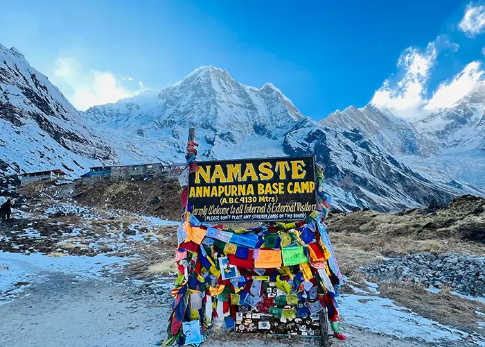
The gorge narrows until it feels like the mountains are leaning in to touch you. This is the “gate” to the Annapurna Sanctuary. As you pass through the gap between the peaks of Hiunchuli and Machhapuchhre, the terrain opens up into a massive, hidden glacial basin. The air here at 4,130 meters is thin enough that every ten steps feels like a sprint. The “stairs” have largely disappeared, replaced by glacial moraine – unstable rock and gravel left behind by retreating ice. It’s a moonscape. But then, you reach the base camp, and the physical toll of the last few days suddenly makes sense.
The Climax: Standing Among the Giants
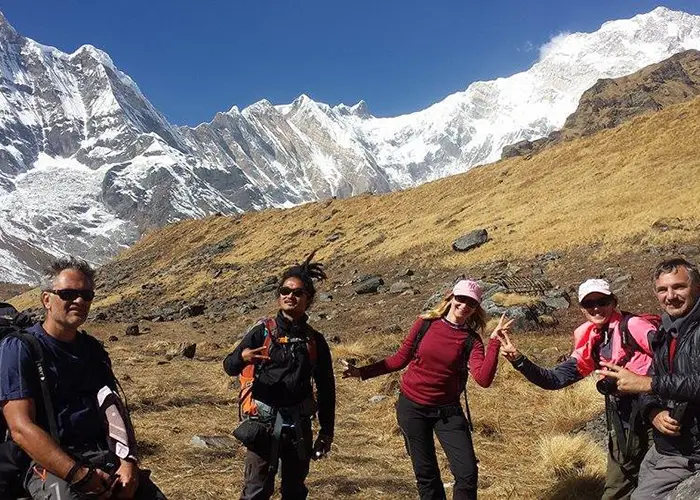
Standing at the Annapurna Base Camp (ABC) is a sensory overload. You are standing in the center of a 360-degree theater of ice. To your north is the massive south face of Annapurna I, the world’s 10th highest peak and a mountain that commands absolute silence. To the south, the sharp pyramids of Hiunchuli and Annapurna South pierce the sky.
The experience is a reward for the 10 days of effort it took to get here. The 10-day duration is perfect for beginners because it allows for proper acclimatization – a necessity when you are sleeping at over 4,000 meters. The silence at the top is profound, broken only by the occasional crack of a shifting glacier. You realize that the 3,300 steps and the humid jungles were just the preamble. They were the friction required to slow your mind down enough to witness the scale of the high Himalayas.
Why the Verticality Matters
Trekking to ABC isn’t a walk; it’s a climb. By the time you retrace your steps back down to Bamboo and eventually reach the natural hot springs at Jhinu Danda to soak your tired muscles, your body will feel different. You’ve moved through five distinct climatic zones in less than a week.
In the modern era of travel, the “Stairs to the Stars” offer a rare opportunity to earn your view. Every vertical meter gained is a conversation with your own limits. This journey is organized by experts like glorioushimalaya.com, a dedicated team based in Thamel, Kathmandu. They understand that while the mountains are intimidating, a well-structured plan makes the 10th highest peak in the world accessible to anyone with enough heart and stamina to take the first step.
Earning your view at an altitude of 4,130 meters is a life-changing accomplishment, but it requires a strong foundation. Organized by the experts at Glorious Himalaya, your journey is backed by a dedicated team in Kathmandu that understands the nuances of the Annapurna trail. From pacing your acclimatization to sharing the stories behind the stone steps, they provide the local support that turns a difficult trek into a seamless Himalayan adventure.


