Peru’s abundance of famed archaeological sites, natural wonders, and world-class gastronomy draws millions of annual visitors. But there are also under-the-radar, little-known places all over the country that could be the highlight of any trip. Here are five secret sites to consider on your visit.
Qhapaq Ñan
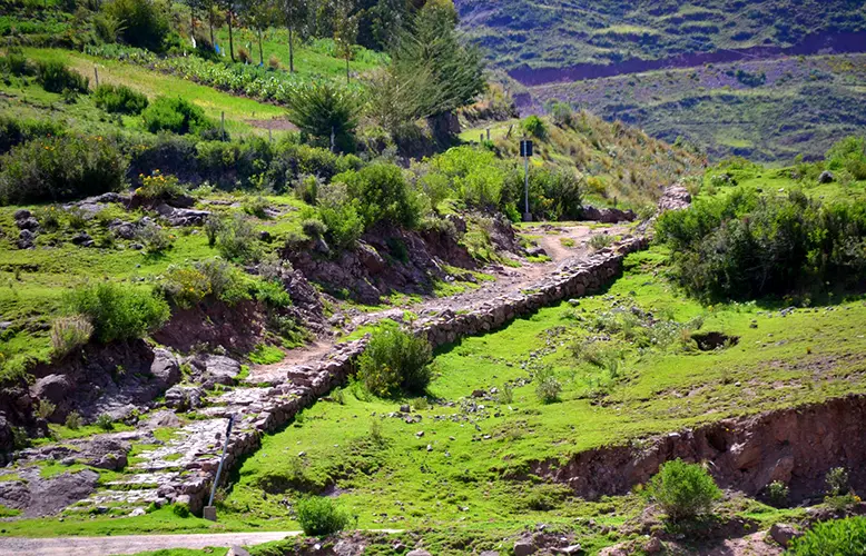
Many thrill seekers aspire to hike the Inca Trail to Machupicchu, which is part of the Qhapaq Ñan Andean Road System, a 19,000-mile network of trails through the vast Inca empire in South America. It is a UNESCO World Heritage Site. But in the Ancash region of northern Peru there’s a beautiful, lesser-known section of the Qhapaq Ñan (meaning “royal road” in Quechua) that qualifies as a once-in-a-lifetime adventure. Like much of the entire network, it includes Inca remains, too. Traverse a rugged stretch of the Peruvian Andes for five days with guides, chefs, porters, and llamas carrying your gear, surrounded by snowcapped mountains more than 21,000 feet high, and you’ll experience rare wonder and a feeling of great accomplishment.
Sarcophagi of Carajía
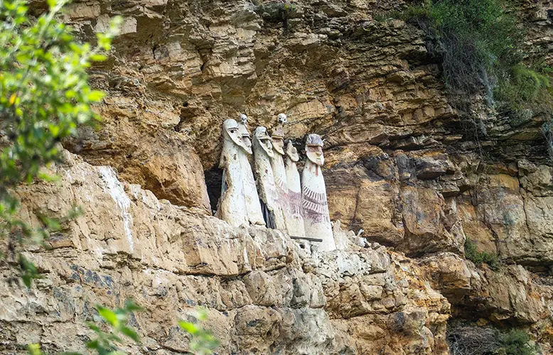
A visit to the town of Chachapoyas, capital of the Amazonas region, would not be complete without a side trip 30 miles northwest to the Sarcophagi of Carajía. The eight-foot-tall coffins constructed from straw and clay in the 15th century were built right into the side of a cliff 700 feet above a river gorge and topped with oversized heads. Some still retain the human skulls anchored to the top of the burial containers for members of the Chachapoyas civilization. Six of the original eight sarcophagi have survived . . . one fell to the base of the gorge during a 1928 earthquake. Mummy remains have been removed from the sarcophagi to preserve what could be saved.
Cumbemayo
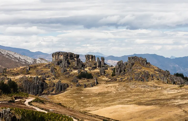
In the highlands of northern Peru about 30 minutes from Cajamarca, there’s a beautiful, fascinating place that offers a combination of geological and manmade wonders. The first sight of Cumbemayo is a stone forest of 60-foot-tall rock pillars shaped by wind and rain and surrounded by gentle grassy plains. Some say the formations resemble silhouetted monks in procession, which inspired their Spanish name, frailones, meaning “friars.”
Another major attraction at Cumbemayo, which means “narrow river” in Quechua, is an aqueduct whose canals are carved from volcanic stone by a pre-Inca society roughly 3,500 years ago. The aqueduct collects and carries melted snow water from the mountains through valleys to Cajamarca along about five miles of zig-zagged canals. Much longer than necessary for irrigation purposes, the elaborate waterway makes many detours that form some geometric shapes, suggesting a purpose beside crop irrigation, such as ceremonial. Research suggests it may have served as a water-worship site. The Cumbemayo aqueduct is considered one of the most important examples of pre-Columbian hydraulic engineering.
Walls of the canals and caves are embellished with mysterious anthropomorphic petroglyphs, believed to have been created between 1,500 and 1,000 B.C. and yet to be deciphered. Other features include a stairway sculpted from stone, a carved rock that once served as a ceremonial altar, and a cliff that resembles a man’s head and whose mouth is a grotto.
Q’eswachaka Rope Bridge
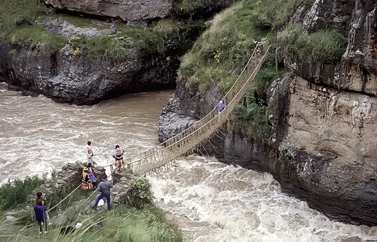
A marvel of Inca engineering beckons 110 miles (almost four hours) south of Cusco 110. The Q’eswachaka Rope Bridge is the only remaining hand-woven Inca rope bridge in South America. Rebuilt every year since Inca times, the 118-foot-long suspension bridge hangs 60 feet above the Apurimac River that runs through the Apurimac Canyon. The bridge has been on UNESCO’s list of Sites with Intangible Cultural Heritage of Humanity since 2013.
Building this bridge started as a group effort — done by women braiding straw material called ichu into thin braids that the men then plait into heavier, braided support cables called q’oya. Such rope bridges were an essential part of the Andean road system, or Qhapaq Ñan, spanning canyons, gorges, and rivers so people and livestock could cross safely. Even Spaniards on horseback crossed some of those suspensions.
Every June, four Quechua communities in the area (Huinchiri, Chaupibanda, Choccayhua, and Ccollana Quehue) rebuild the bridge, a tradition that honors Inca history and engineering. First, the old, braided cables and platform are released to float down river and decompose. Only men are allowed to create the six new three-ply ropes that measure one-foot thick, composed of 120 thinner braids. Four of these large, braided cables will form the platform of the bridge and supports that are tied to stone abutments on the riverbanks, while the other two are used for handrails. These communities are so skilled and collaborative that by the second day, men start installing the bridge platform and railings. On day three, narrow braided cords are installed between the railings and platform for safety, and the master builders walk from both sides of the bridge to meet in the center and proclaim the Q’eswachaka safe for crossing. The rope symbolizes the connections between these Quechua communities and their shared traditions. Afterward, there’s a blessing offered to the mountain spirits, along with music and a feast.
Caral
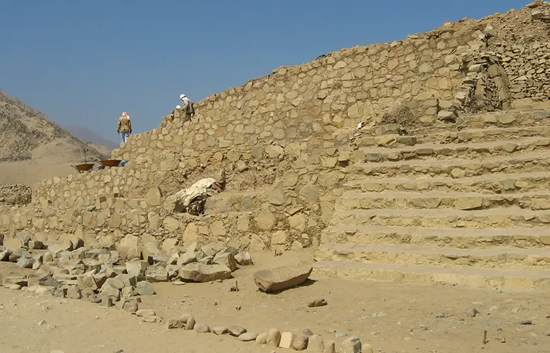
You can visit the oldest city in the Americas, which was established before the invention of metal or kiln-fired ceramics, before the Maya and Inca civilizations, possibly before Egypt’s first pyramids were being constructed. Three-and-a-half hours north of Lima, Caral (also known as the Sacred City of Caral-Supe) was buried under desert dunes when first rediscovered in 1905. But excavations on the mud brick and stone structures didn’t begin for almost a century because archaeologists first thought the site was fairly recent. It was the mid-1990s when excavations revealed the scope of the complex that contains six pyramids, sunken circular plazas, stairways aligned with the stars, multiple temples including one that was 90 feet tall, sunken amphitheaters, palaces and residences for the elite, and underground irrigation channels, built nearly 5,000 years ago — 1,000 years earlier than any known urban center in the Americas. The largest, 60-foot-tall pyramid has a base the size of four football fields.
In its prime between 3,000 and 1,800 BC, Caral was abandoned for unknown reasons. Archaeologists have not found any city walls or fortifications, weapons, or destruction that would indicate a battle. They believe the well-preserved complex demonstrates advanced city planning and a knowledge of astronomy as well as an agricultural society that grew squash, sweet potatoes, beans, and cotton, and that traded goods with coastal communities in the jungle and central highlands. A UNESCO World Heritage Site, Caral is free of crowds.


