
Rhodes sits at the south-eastern edge of the Aegean, closer to the Turkish coast than to Athens, and that position shapes how the island works in summer. The medieval walled city on the northern tip pulls most of the attention, but the island has a 220-kilometre coastline, a forested interior, and a scattering of smaller islands nearby. The notes below cover six practical ways to spend time here, starting from the water.
Rhodes Boat Hire
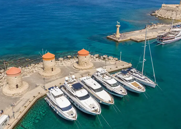
The main base for charter departures is Mandraki Harbour, the historic port directly north of the Old Town. A second, larger base operates at Rhodes Marina adjacent to Mandraki — purpose-built, with fuel, water, chandlery, and proper haul-out facilities. Most bareboat flotillas and privately booked boats check in from here. A third option is the commercial port further south, but it handles freight and ferries rather than leisure craft and is rarely used as a charter base. Here you can chart a yacht in Rhodes.
The dominant summer wind in the Dodecanese is the meltemi, which funnels through the Aegean from the north and reaches the southern islands as a consistent northerly or northwesterly force 4–6. In the straits between Rhodes and Kos it accelerates, so the typical weekly itinerary heads south or east first and works back upwind at the end of the week, or keeps to the sheltered lee shores. The Turkish coast across the straits — Marmaris, Bodrum, the Bozburun peninsula — is accessible in 15–25 nautical miles from Mandraki, and the combination of Greek islands and Turkish harbours makes for one of the best dual-country cruises in the eastern Mediterranean. Clearing customs at either end adds a few hours but is routine.
Within Greek waters, the Dodecanese island chain is the natural playground. Kos is roughly 45 nm north-northeast, Halki is a short 15 nm hop south-west, Tilos lies about 40 nm north-west, and Symi — the most popular day anchorage from Rhodes — sits just 22 nm north, with a row of neoclassical houses rising straight out of the water at Yialos. Further out, Nisyros has a live volcanic crater accessible from its port, and Kalymnos is the traditional sponge-diving base and now a sport-climbing destination.
If you want to hire a boat in Rhodes and compare available models for your dates, here is the operator’s website lists current options.
Mandraki has a practical advantage: provisioning is straightforward, with a covered market and a supermarket within ten minutes on foot. Fill water and ice before leaving, since anchorages on smaller islands often have no facilities. September brings slightly lighter conditions and clearer underwater visibility than the peak meltemi months.
Old Town Walks
The Rhodes Old Town is a UNESCO World Heritage Site and the largest inhabited medieval city in Europe. The walls — built and extended by the Knights of St John between 1309 and 1522 — stretch nearly four kilometres around a roughly rectangular footprint and enclose a working neighbourhood of around 6,000 residents. Entering through the Gate of St John or the Gate of d’Amboise in the northwest gives the clearest first impression of the scale.
The main axis through the walled city runs down Odos Ippoton, the Street of the Knights, a well-preserved medieval street lined with the inns of the different national tongues of the Knights Hospitaller. Most of the facades date from the 15th and 16th centuries and are unusually intact — the Ottoman governors who took the city in 1522 kept the structures largely undamaged. At the top of the street, the Palace of the Grand Master was substantially rebuilt in the 1930s and houses two floors of mosaic floors taken from Kos, plus collections of medieval furniture and ceramics.
The Turkish and Jewish quarters in the southern part of the Old Town are quieter and more residential. Suleiman Mosque and the adjacent Ottoman library sit at the top of Sokrates Street, the main commercial lane. The Jewish Quarter at the far southeast end of the walled city centres on Martyrs Square, where the surviving community synagogue — Kahal Shalom, the oldest in Greece — remains open for visits.
Walking the walls is possible on a section from the d’Amboise Gate toward the St George Tower, with views over the old harbour and the residential areas beyond. Allow two to three hours for a thorough walk, more if visiting the palace museum. Before 10:00 and after 18:00 are noticeably cooler and less crowded.
Dodecanese Food Culture
The cuisine of Rhodes reflects its layered history: Greek Orthodox, Ottoman and Sephardic Jewish traditions have all left practical traces on the table. A few things are specific enough to be worth tracking down.
Pitaroudia are chickpea fritters — ground dried chickpeas mixed with onion, herbs and sometimes tomato, fried in olive oil. They appear as a meze starter in most traditional tavernas and are the closest thing the island has to a signature street food. Macarounes are hand-rolled pasta dressed with soft cheese and caramelised onions, a dish more common in the interior villages than on the tourist waterfront. In the fishing ports — Kameiros Skala on the west coast, Lindos in the south-east — grilled fish and octopus are the default order and the quality is generally reliable.
The island produces wine mostly from the Athiri grape, a light dry white. Winery visits are possible around Embonas village in the interior. Olive oil from the Rhodian groves is worth buying directly — the covered market in Rhodes Town is the simplest place to compare labels.
Hiking in the Interior
The forested interior of Rhodes is rarely on the average tourist itinerary, which means the trails are uncrowded even in July. Mount Attavyros, at 1,215 metres the highest point on the island, offers a clear-day view that takes in Kos, Tilos, Halki and the Turkish coastline on a single horizon. The ascent starts from Embonas village and is roughly eight kilometres return on a marked path, gaining about 800 metres. The summit ridge is exposed and the last section is loose rock; start before 08:00 in summer to avoid the midday heat.
Lower down, the Valley of the Butterflies — Petaloudes — is a nature reserve on the west coast roughly 25 kilometres from Rhodes Town. From June to September the valley fills with Jersey tiger moths (commonly called butterflies locally), which congregate on the plane and storax trees beside a shaded stream. The walk through the reserve is short, shaded, and suitable for all fitness levels. Note that loud noise or camera flashes disturb the moths — the reserve asks visitors to stay quiet on the path.
Beach Days
Rhodes has more than a hundred beaches by most counts, ranging from the wind-scoured sandy stretches on the north-east coast to sheltered pebbly coves in the south. The contrast matters for planning: the north-east beaches face into the meltemi and are the windsurfing spots in season, while the south and west coasts are calmer in the afternoon.
Prasonisi, at the southern tip of the island where the Aegean and Mediterranean meet, is the best example of this split: the east side is the kitesurfing and windsurfing beach, the west side is calm and swimmable. Several schools operate here with rental equipment and lessons. The sandy spit connecting the beach to the rocky headland floods at high water in winter and is dry in summer, giving a curious double beach effect.
Closer to the capital, Elli Beach runs along the northern tip beside the town and is an easy walk from Mandraki Harbour. Faliraki further down the east coast is the largest organised beach on the island, with the full infrastructure of sunbeds, water sports and beach bars. For something quieter on the same coast, the coves around Ladiko and Anthony Quinn Bay — named after the actor who filmed here in the 1960s — have clearer water and fewer facilities, accessible by a short path from the road.
Lindos and the South Coast
Lindos is the most visited site outside Rhodes Town, and justifiably so. The village of white-painted cubic houses climbs a steep hill capped by the Acropolis of Lindos, where a Doric temple of Athena Lindia — built in the 4th century BCE and expanded by the Knights — overlooks both the main bay and a second smaller beach to the north. The ascent is partly on stone-cut steps and partly on a donkey path; the view from the top justifies the climb.
The village at the base of the hill is traffic-free and busy from June through September. Visiting before 09:00 or in the early evening, after the day-trip coaches have left, makes the lanes navigable. The main beach below is a wide sandy bay — protected from the north by the headland and one of the more reliably sheltered spots on the east coast.
Further south, the coastline approaching Prasonisi becomes noticeably quieter and largely undeveloped — a different register from the organised north entirely.


